Also: Divin, Drogichin, Khomsk, Malech, Telechany

 |
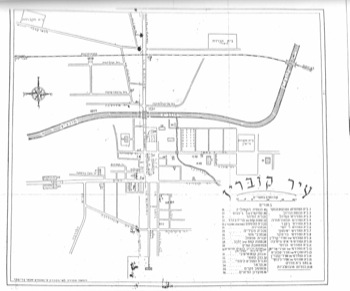
| The map in "Kobryn 1951b". At bottom left: Drawn by Shabtai Zaritsky, Engineer, 1951 |
 |
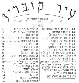
| The map in "Kobryn 1951b". Note distance scale below title line. |
| 1 | Building of institutes and youth movements. |
| 2 | The big synagogue |
| 3 | The big Bet Midrash |
| 4 | Bet Midrash Talmud-Torah |
| 5 | Bet Midrash Ratner |
| 6 | Bet Midrash R’ Yoshi |
| 7 | Bet Midrash Yaponski |
| 8 | Bet Midrash Brisker |
| 9 | Bet Midrash of Karlin Hassids |
| 10 | Bet Midrash Khayey Adam the Yeshiva |
| 11 | Russian Bet Midrash |
| 12 | Bet Midrash of Trisk Hassids |
| 13 | Bet Midrash of Slonim Hassids |
| 14 | Bet Midrash of Kobrin Hassids |
| 15 | Bet Midrash of Libushi..Hassids |
| 16 | Bet Midrash street |
| 17 | Provoslav church |
| 18 | Provoslav church |
| 19 | Catholic church |
| 20 | Barracks of Givgot |
| 21 | Prison |
| 22 | Flour Mill of Breidboard |
| 23 | Court house (ruins of cloister) |
| 24 | Shops |
| 25 | Municipality House |
| 26 | Fire Brigade |
| 27 | Pantol’s house |
| 28 | Flour Mill of Yadvab |
| 29 | Water pump |
| 30 | Memorial monument for the Russians victory over Napoleon |
| 31 | Cooperative Bank |
| 32 | Public/folk Bank |
| 33 | Jewish Hospital |
| 34 | Post office |
| 35 | Old people’s Home |
| 36 | Zionists Club |