Also: Divin, Drogichin, Khomsk, Malech, Telechany

 |
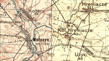
| Gremyatshe -- Hremiacze Text under Kol. [Colony] Hremiacze, “Szk” means School. Combination of 2 inter-war 1:100,000 scale maps, courtesy of mapywig.org |
| Editor's Note: Government High-School: By definition, a Polish school. Besides the map notation, the existence of a school in this tiny farming community cannot be confirmed. The approximate distance from central Volchin to Kol. Hremiacze is 3.5 km (2.2 miles). Hannah Kremer, a Jewish survivor of Volchin, tells of attending the high-school in Wysokie Litewskie because there was none in Volchin. Depending on the timing, that may not be consistent with the fact that Shmuel Englander attended a high school not far from Volchin. |