The Brest-Belarus Group
small-area-map
Also: Divin, Drogichin, Khomsk, Malech, Telechany
 
Table of Contents  (?)
Site Page Counts
Public: 510
Restricted: 677

Shmuel's Map -- Southeastern Section
The southern end was populated chiefly by Belarusians whose religion was Provoslav [Russian Orthodox]. They had a beautiful church, renovated and exists today as well.

Pulva
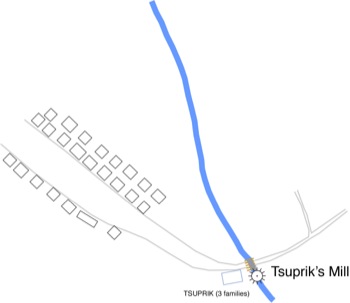
Shmuel Englander's Map, redrawn; in English.
South-Eastern Section: “Old/Provoslav Volchin”
View Map Key
View Shmuel's Original of this Section

[Added by the editor:] This map shows the South-Eastward continuation of Volchin's main street, shown in exaggerated scale. As the distance from the center of Volchin increases, the road returns to more reasonable --and probably more accurate-- scale. There was a bridge at the river crossing, with the TSUPRIK families dwelling together near their mill, the only Jewish family in this part of Volchin.

Editor's Note: beautiful church: The Provoslav Church is actually in the central, formerly Jewish section of Volchin. In the region today, it is not unusual to find Russian Orthodox or Polish Catholic churches in the midst of a formerly Jewish area. Tsuprik mill: I have spoken with a surivor of Volchin who recalls as a child riding her bicycle from the village to the mill to visit her relatives there. The distance would be about 1 km (0.6 mi).

Page Last Updated: 02-May-2013