Table of Contents
(?)
Site Page Counts
Public: 510
Restricted: 677
//add in logic required to do stories on each page
require_once './include/story_page_include.php';
include "./include/story_page_nav.php"
?>
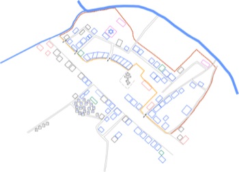
The Ghetto was enclosed with a wooden fence along the main street (orange dashed line in graphic) and iron wire fence (red dashed line) along the rest. The guards along these fences were residents of the town.
The Gates
Gate 1: the northern-most, was opposite the [formerly Polish] gmina administration office. Used by administration clerks, policemen, and ghetto guards.
Gate 2: the main gate, used by carts, going out to work, passage to herds of cows and horses (owned by policemen and administration personnel) to go to the pasture and bathing in the river.
Gate 3: the marketplace gate gave access to the Jews to the water well in the marketplace, at times negotiated with the municipal administration.
Gate 4: the southernmost gate was used for transferring food in for distribution. The distribution center was the former post office, now the Judenrat office. At night this gate was used to carry out bodies of the dead to the Jewish cemetery.
//add in logic required to do stories on each page
require_once './include/story_page_include.php';
include "./include/story_page_nav.php"
?>
Editor's Notes: Not shown on Shmuel's map, there was a water well by the Synagogue, well inside the Ghetto. (It still exists to this day.) It isn't clear why the residents could not fetch water from it without leaving the Ghetto. Perhaps it was closed by the Nazis in order to exert complete control over this necessity. Captions on households and businesses within the Ghetto are purposely omitted from the map as typically the Nazis paid no attention to prior ownership. The ghetto seems larger than the proportion ordinarily used by the Nazis. Shmuel followed the descriptions of the Gentiles he interviewed in 1997, including references to the Jewish inhabitants of the houses that marked the borders. Actual size: measured on a modern Google Earth map, the long dimension of the Ghetto was approximately 0.45 km (0.28 mi, or 1500 ft.); using this estimate, the area of the Ghetto was probably somewhat smaller than 0.05 km2 (0.02 square miles). |